
A record exists.
Someone reported the fungus with enough location information to connect the observation to an Alabama county.

MUSHROOM DISTRIBUTION MAPS Where have we actually found them?These maps combine mushroom records from across Alabama to show where particular fungi have been documented—and where there are still conspicuous gaps in what we know. READ THE BLANKS CAREFULLY No record does not mean no mushroom.These are maps of documented observations—not perfect biological range maps. A highlighted county tells us that someone has recorded the fungus there. An unhighlighted county may mean the fungus is genuinely absent, but often it simply means nobody has contributed a usable record yet. That distinction is especially obvious with common mushrooms such as chanterelles. Many species groups almost certainly occur much more widely across Alabama than the current records suggest. WHAT THE MAPS SHOW Occurrence, effort & unanswered questions.A record exists.Someone reported the fungus with enough location information to connect the observation to an Alabama county. We haven't necessarily looked.Sparse records can reflect low observer activity, incomplete reporting, short fruiting windows, or difficult identification. Clusters can still teach us something.When records consistently concentrate in one part of Alabama, habitat, climate, geology, host trees, or actual biological range may be contributing. THE MUSHROOMS PEOPLE SEARCH FOR Edibles make excellent distribution questions.People pay close attention to where morels, chanterelles, chicken of the woods, and hen of the woods occur. That interest creates useful records—but the patterns are still incomplete.
CHANTERELLE GROUP Red chanterellesCantharellus cinnabarinus group The AMS map groups closely related red chanterelles, including fungi treated as C. cinnabarinus, C. texensis, and related taxa. Chanterelles can be difficult to resolve to species from field appearance alone, so mapping species groups is often more defensible than pretending every observation has been identified with microscopic or genetic certainty.
The important pattern:
Blank counties here are especially likely to
represent missing records rather than true absence.
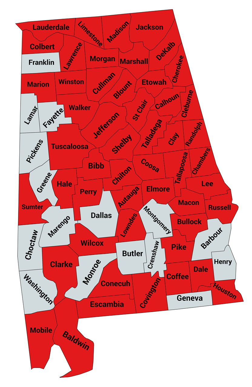 Open map full size →
CHANTERELLE GROUP Golden chanterellesThis broad map combines several yellow and golden chanterelle groups, including smooth chanterelles, Cantharellus minor, members of the C. cibarius group, and the documented C. persicinus record. It is intentionally a practical distribution map, not a claim that every observation has been resolved to a single species. 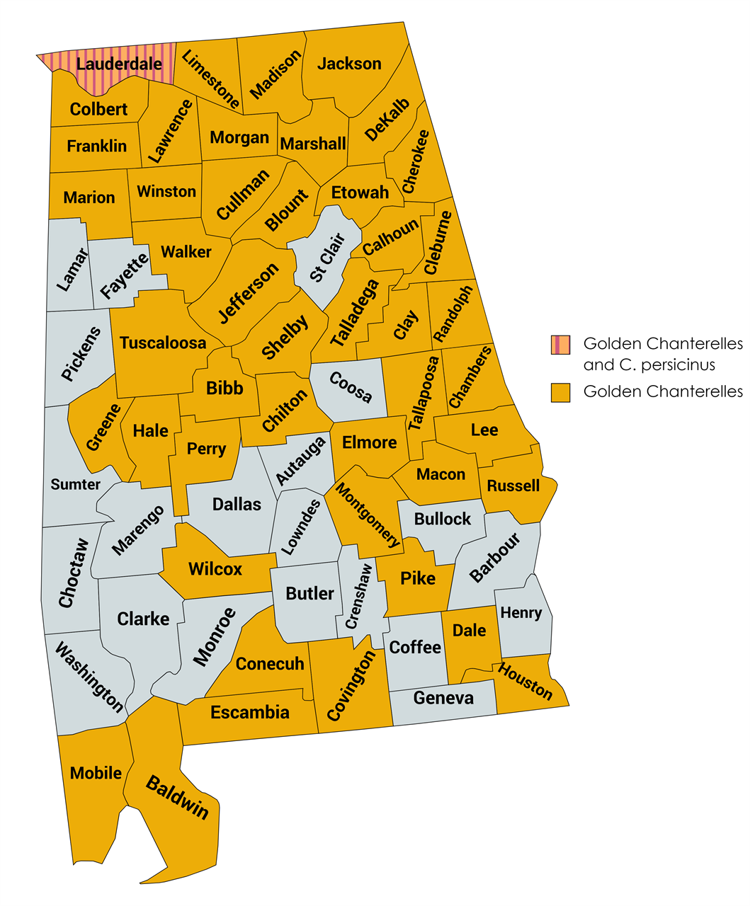 Open map full size →
SPRING MorelsMorchella species The Alabama morel map shows one of the clearest north–south patterns in the current AMS collection. In the dataset used for this map, four morel species were represented in Alabama. Morchella americana was by far the most frequently documented, followed by M. diminutiva. Records of M. sceptriformis were much scarcer, and only one M. punctipes record was represented. Most observations occurred north of roughly the Fall Line, with very few records in the southernmost counties. 


 Open morel map full size →
MORE SOUGHT-AFTER EDIBLES Some ranges tighten as you move south.NORTHERN ALABAMA Hen of the woodsGrifola frondosa Hen of the woods is better associated with northern climates and has a relatively brief fruiting window in northern Alabama. This is the kind of mushroom where a geographically concentrated map may represent genuine biology as well as differences in observer effort. 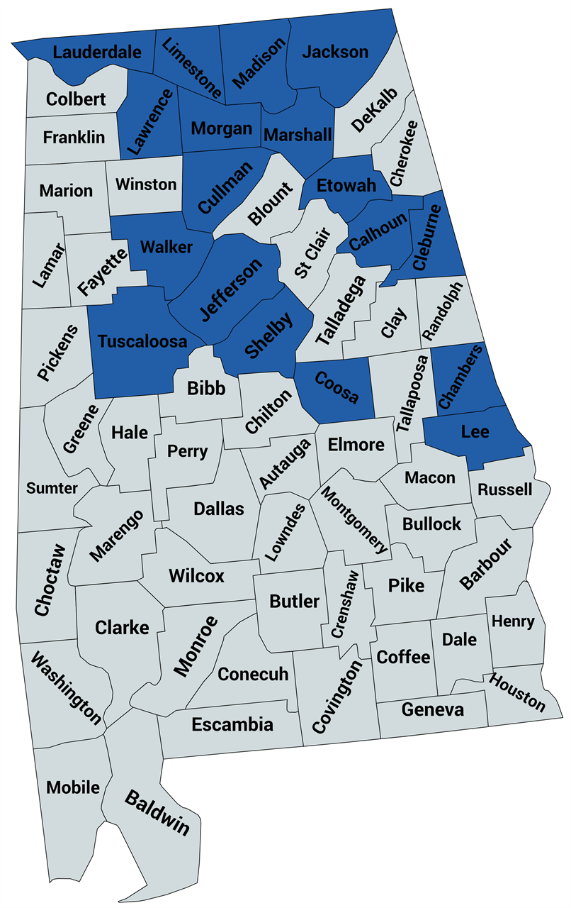 Open map →
MULTIPLE SPECIES Chicken of the woodsLaetiporus species The current AMS records document Laetiporus cincinnatus and L. sulphureus in Alabama. L. gilbertsonii var. pallidus may occur in the far south, but the existing AMS map notes that reliable documentation was still lacking when the map was assembled.  Open map →
WHY LOCAL RECORDS MATTER Macrocybe titans broke the databases.When this AMS map was assembled, the major databases being checked contained zero Alabama observations. AMS had thirteen. Those Alabama records had been reported through the society's Facebook community rather than the major biodiversity databases. One extraordinary specimen documented by AMS was reported at roughly two to three feet tall, with a cap approximately two to three feet across, and was examined in person by an AMS board member. This is exactly why local naturalist communities can matter scientifically. An organism may already be known to people on the ground while remaining nearly invisible in formal occurrence databases.
0
Alabama records in the major databases checked
when the map was compiled
13
Alabama observations documented through the AMS
Facebook community
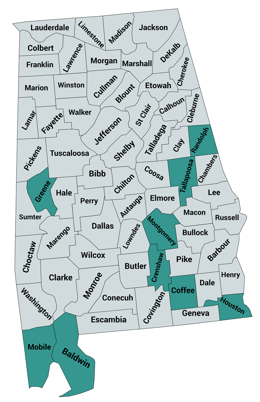 Open Macrocybe titans map full size →
THE EDGES ARE INTERESTING Rare, uncommon—or simply under-recorded?Sparse maps are often where the questions become most interesting. SUMMER Black-staining polyporeMeripilus sumstinei Existing AMS records suggest a distribution concentrated in roughly the northern two-thirds of Alabama. The current map specifically points to a band of unhighlighted counties between the Sumter and Lee County areas as likely places where the fungus may occur but simply has not yet been documented. 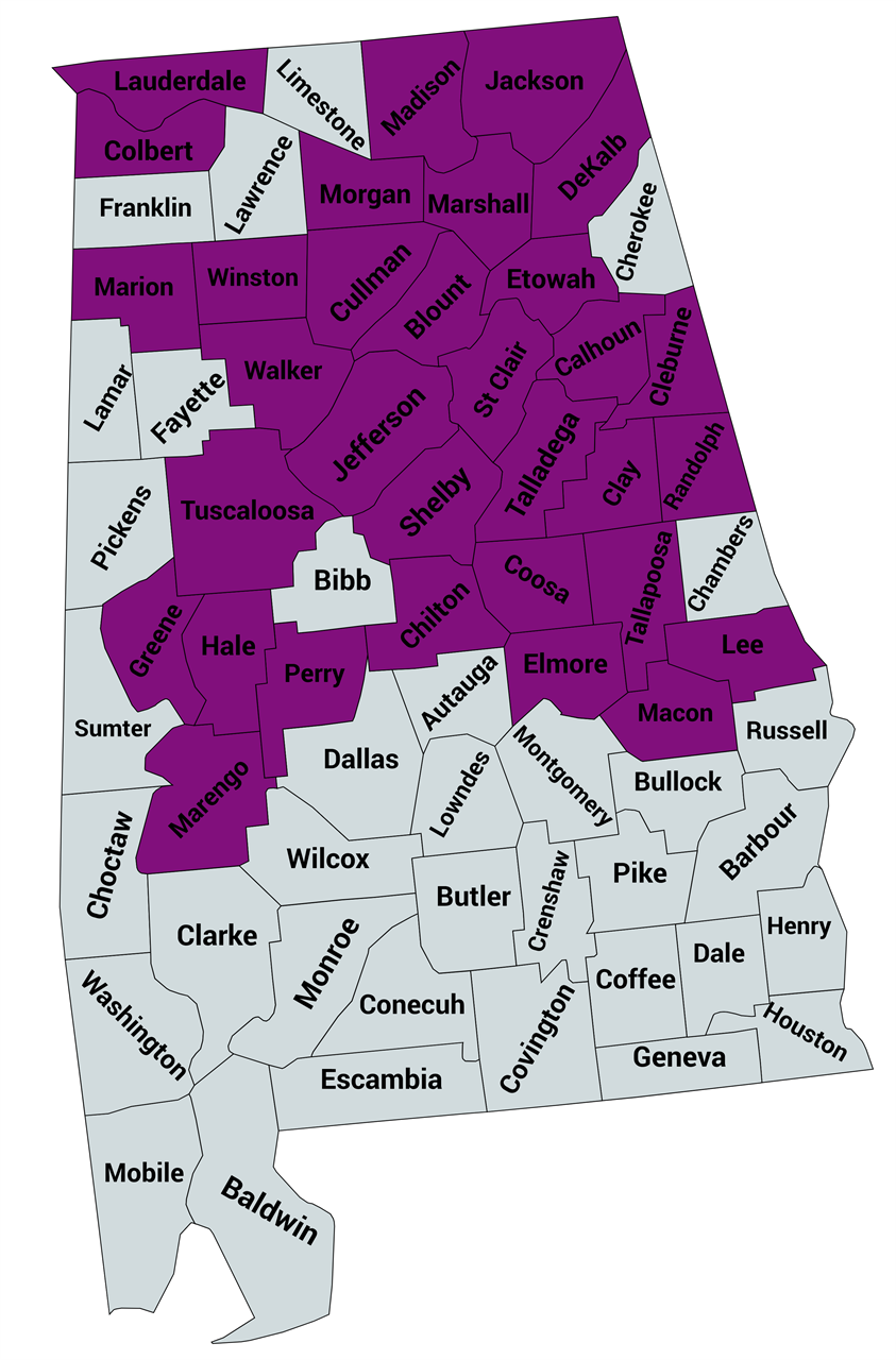 Open map →
UNDER-RECORDED Umbrella polyporePolyporus umbellatus This unusual fungus was represented by reports from only six Alabama counties in the data summarized on the existing AMS page as of October 2023. AMS suspects it is more common across northern Alabama than that sparse record currently makes it appear. 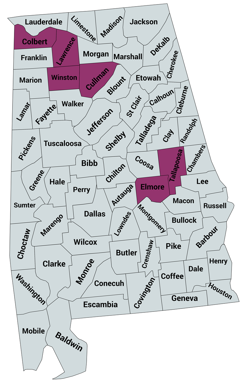 Open map →
WHERE THE RECORDS COME FROM More than one database.AMS built these maps by combining formal biodiversity records with observations reported by Alabama's mushroom community.
AMS community reports
County-level observations reported through the Alabama Mushroom Society Facebook community.
iNaturalist
Public observations that provide photographs, dates, locations, and community identification.
Mushroom Observer
A long-running community database focused specifically on fungi.
MycoPortal
Herbarium and specimen-based fungal records from natural-history collections. SEE AN EMPTY COUNTY? Good. Go look.A gap in the map is an invitation to collect better information. If you find a mapped species in a county where no observation is currently represented, photograph it carefully and create a durable record.
FROM PIN TO SPECIMEN Make the record stronger.A mapped observation can tell us that a fungus was reported somewhere. A well-documented AFDP collection can add photographs, habitat information, morphology, a voucher specimen, and sometimes DNA. Those pieces make future identification and research much more powerful. KEEP LOOKING Explore Alabama. Add what you find.Every useful record makes the next version of these maps a little better. |